

Directions | Google Map | Campus map
Directions
Via U.S. Highway 101
- From the north or south, take US-101 toward Ventura, exit California Highway 126 East toward Santa Paula.
- Travel east on CA-126 for about 12 miles, then take the 10th Street exit in Santa Paula.
- Turn left onto 10th Street. At the fourth traffic signal (the cross-street is Santa Paula St.), bear slightly to the right; at this point 10th Street becomes Ojai Rd./CA-150.
- You are approximately five miles from the campus. Watch for the entrance to Thomas Aquinas College on the right-hand side of the road.
Via Interstate 5
- From the north or south, take I-5 toward Santa Clarita, exit California Highway 126 West toward Ventura.
- Travel west on CA-126 for about 28 miles, then take the 10th Street exit in Santa Paula.
- Turn right onto 10th Street. At the fourth traffic signal (the cross-street is Santa Paula St.), bear slightly to the right; at this point 10th Street becomes Ojai Rd./CA-150.
- You are approximately five miles from the campus. Watch for the entrance to Thomas Aquinas College on the right-hand side of the road.
Google Map
Campus Map
Printable version (PDF)
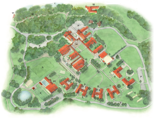
| Campus Buildings | |||
| 1 | St. Augustine Hall (classrooms) | 12 | St. Gladys Hall (classrooms) |
| 2 | Albertus Magnus Science Hall | 13 | St. Cecilia Lecture & Concert Hall |
| 3 | St. Joseph Commons | Ken & Joyce Skinner Coffee Shop | |
| 4 | St. Katherine of Alexandria Hall | 14 | Our Lady of the Most Holy Trinity Chapel |
| 5 | St. Bernard of Clairvaux Hall | 15 | St. Thomas Hall (adminstration / faculty) |
| 6 | Guest Lodging | Bookstore | |
| 7 | St. Thérèse of Lisieux Hall | 16 | Stations of the Cross |
| 8 | St. Monica Hall | 17 | Gate House |
| 9 | Sts. Peter and Paul Hall | 18 | Hacienda |
| 10 | St. Junipero Serra Hall | 19 | Loyola Hall |
| 11 | St. Bernardine of Siena Library | 20 | Pope St. John Paul II Athletic Center |
| Parking & Recreation | |||
| a | Tennis/Basketball courts | b | Athletic field |
| c | Hacienda ponds | d | Founders Plaza |
| e | St. Gladys Plaza | P | Parking |